The Church of the Good Shepherd is a small, picturesque stone church located on the shores of Lake Tekapo. It is renowned for its stunning natural setting and is one of the most photographed buildings in New Zealand. Built in 1935 as a memorial to the early settlers of the Mackenzie Basin, it was constructed using local stones gathered within a five-mile radius and blends seamlessly into its surroundings.
Pictured below is a recently constructed footbridge across the Tekapo River. Completed in 2015, the bridge spans 410 feet and stands 410 feet above the water. We have seen many bridges in New Zealand, and I would have to say this is probably my favorite.
In the news on the home front, the product that Maya has been working on at Formlabs was just announced. See the video below. Kyle has taken up Salsa and Bachata dancing, and Nicolai will be playing amputee soccer at Gillette Stadium on April 19th.
Aoraki / Mount Cook is New Zealand’s tallest mountain at 12,218 feet. When we arrived at the Mount Cook Village last night, clouds obscured all of the mountains. This morning, I chose to hike the Hooker Valley Track while Jeanine opted to relax with a book at the Hermitage Hotel since the skies were heavily overcast and threatening rain. I really enjoyed the 6.8 mile hike out to Hooker Lake even though it remained cloudy all morning. Fortunately, I did get a 5 minute window where the clouds opened up in front of Mount Cook. The same thing happened again when we were driving out of the park.
The Moeraki Boulders are large, spherical concretions formed from mudstone, a type of sedimentary rock, approximately 60 million years ago during the Paleocene era. These boulders, which can reach up to 3 meters in diameter and 7 tons in weight, were created through a process of sedimentation and mineralization on the seafloor, and were later exposed by coastal erosion along Koekohe Beach. Optimal time for photography is during mid-tide which required an early departure from Dunedin. We drove through rain for much of the way but it stopped as we arrived in Moeraki only to start again after I captured my final images. This good fortune did not persist, however, as rain and low clouds greeted us as when we arrived at Aoraki / Mount Cook later in the day.
Nugget Point Lighthouse, located near the mouth of the Clutha River is a historic lighthouse built from locally quarried stone between 1869 and 1870. It is situated high above a collection of massive rocks jutting up from the sea. We stopped here for the views and to breakup the 6 hour drive from Milford Sound to Dunedin.
Along the drive, we encounter some pretty impressive sheep farms. Click on the image below and just try to count the sheep.
We arrived in Dunedin by late afternoon and stopped to explore the Dunedin Railway Station, a prominent architectural landmark of the city, known for its Flemish Renaissance style designed by George Troup, who earned the nickname “Gingerbread George” for his work on the building. Opened in 1906, it was once New Zealand’s busiest station but now primarily serves as a tourist hub, hosting and housing attractions such as the New Zealand Sports Hall of Fame and the Otago Art Society.
We then made a brief visit to Baldwin Street, deemed to be the steepest residential street in the world. We did not dare drive to the top and I only walked a short distance to take this photo on the shallowest part of the drive.
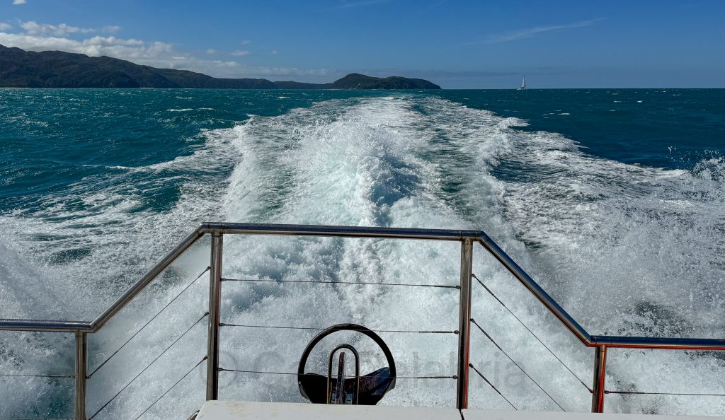
Arguably, the pinnacle of our vacation was an overnight cruise in Milford Sound. Milford Sound is actually a fjord renowned for its breathtaking landscapes, featuring sheer rock faces, powerful waterfalls like Lady Bowen and Stirling Falls, and a unique ecosystem supported by its high rainfall, which creates a freshwater layer on the surface of the fjord, allowing for diverse marine life to thrive. Our home for the next 18 hours is the Discovery Jewel, a state-of-the-art cruiser that sleeps 18 guests and 4 crew.
During our tour of the fjord, we encountered a pod of bottlenose dolphins. At one point, they were swimming underneath the bow of the ship. As I looked over the railing, I saw one of the dolphins swimming on its side, looking up directly at me with one eye. There is no doubt in my mind whatsoever that I was making eye contact with a sentient being.
We also encountered several seals as we traveled close to the large boulders where they like to sun themselves.
I joined a handful of other passengers who elected to stay on the foredeck as the captain pushed the nose of the boat underneath Stirling Falls. My top stayed dry due to my waterproof shell, but my pants got soaked through and through. Fortunately, they lived up to their billing as being fast drying. In the evening, we enjoyed a three-course meal prepared by the ships chef followed by a video presentation narrated by the captain. His grandfather had assisted oceanographer Jacques Cousteau with some of his research and his father had invested in an underwater ROV (remotely operated vehicle) to survey the bottom of the fjord. He was responsible for the discovery of several new species of sealife. The video included underwater ROV footage and aerial drone photography of the sound.
The drive to Milford Sound was as dramatic as the cruise that followed. It is sprinkled with stunning views, including this one of Christie Falls.
Doubtful Sound got its name from Captain James Cook during his voyage in 1770. Initially, he named it “Doubtful Harbour” because he was uncertain whether it was navigable under sail due to the prevailing westerly winds, which made it doubtful that a ship could sail back out once entered. Later, the name was changed to “Doubtful Sound” by whalers and sealers in the 19th century. The Māori name for the fiord is “Patea,” meaning “place of silence,” which reflects its serene and tranquil environment. Today, we experienced it from the water. At 7 AM we boarded a water taxi to cross Lake Manapouri arriving at West Arm where we boarded a bus to take us over Wilmot Pass. We then boarded a cruise which took us up the sound and out into the Tasman Sea before returning 3 hours later.
During the voyage, we encountered waterfalls, short-tailed albatross, seals, and a man in a wet suit poised precariously on the side of a cliff.
This guy was a total mystery, even to the crew. (1) How did he get there? There is no access by car, no place to land a helicopter, no sign of a boat, and it would take days to reach on foot. (2) How did he get onto the face of that rock? (3) What was he there for? Presumably, to dive into the water. Then what? There is no conceivable way of climbing back on shore.
When we reached the Tasman Sea, the smooth ride we had enjoyed turned into a very choppy affair. It became doubtful I would keep my lunch down but my stomach calmed when we returned to the sound.
Te Anau is a picturesque town in Fiordland National Park, known for its stunning natural beauty and as a gateway to Milford Sound and Doubtful Sound. It will be our hub of operations for the next two nights. After driving here from Queenstown we hiked a section of the Kepler Track along the shore of Lake Te Anau. We had hoped to see more birdlife but the only flying object I captured is the butterfly below.
Our next stop was the Punanga Manu Bird Sanctuary, where our birding options improved. Pictured below is one of 10 Antipodes Island Parakeets remaining on mainland New Zealand. There are thought to be less than 2000 in the world. Ducks on the other hand, are everywhere.
Next, we traveled to the Rainbow Reach Bridge to sample a different section of the Kepler Track.
Finally, based on a map view of the Waiau River, I decided that a section called the Baloon Loop would make for a great aerial photo. We located a gravel road that took us to the edge of the river within drone range, and I was able to get the shot. A higher angle would have been even better, but I wanted to keep my altitude low because of the proximity to a nearby airport.
If you are looking for a hub to book adventure activities or where you can find a wide range of really fine food and shopping options, Queenstown is the place. We gravitated to the Queenstown Gardens, which offered a nice respite from the commercialism of the city.
In the afternoon, we drove out to the Kawarau Gorge Suspension Bridge, where a bungee jumping company operates. Click on the image below and see if you can find Waldo. I was tempted to take a leap but the last time I bungee jumped, I had a headache for several days. This operation recovered the jumper with a boat, which was much faster than hoisting back to the top (the method used when I jumped, leaving me inverted for more than 10 minutes.)
After watching the adrenaline junkies for a while, we drove to Lake Hayes and did the 5-mile hike around it bringing our total distance covered for the day to 8.5 miles.
Glenorchy is a picturesque settlement at the northern end of Lake Wakatipu in New Zealand’s Otago region, known for its stunning natural beauty and outdoor activities. The area has been featured in several films, including The Lord of the Rings and The Chronicles of Narnia. We arrived shortly before noon with intermittent rain and high winds to hike the Glenorchy Scenic Lagoon Track. Low clouds diminished the views of Mont Bonpland but did not detract form the plentiful birdlife in the area.
The Arrowtown Chinese Settlement, established during the Otago Gold Rush of the 1860s, was a small community of Chinese miners and merchants living on the fringes of Arrowtown. By 1885, it had grown to include about 10 huts, a large social hall, at least two stores, and extensive gardens, serving as a hub for Chinese immigrants who faced discrimination and lived separately from the European settlers. We stopped here to tour the settlement during the morning. You could argue that the tiny huts built into the sides of a mountain were the inspiration for Hobbit Holes.
The photo below was taken from the roadside on our drive to Glenorchy. Even with the sunlight muted by clouds, I loved the color and composition and am happy I stopped for it (not always easy when traffic is moving along at 100km per hour.)
We arrived in Wanaka last night, where, for the first time, we are staying in a tiny house. Of our accommodations thus far, it is our favorite. It is nestled on a hillside overlooking Lake Wanaka with a small pond below the porch. I got up before sunrise to capture the famous Wanaka Tree. The tree started its life over 80 years ago as a willow branch used as a fence post in Lake Wanaka to keep livestock from wandering. Over time, it took root and grew into the solitary tree seen today. In 2014, a photograph of the tree by Dennis Radermacher won the New Zealand Geographic photo of the year award. The image, taken on a misty day, captured the tree’s unique appearance and set it on the path to fame as #ThatWanakaTree spread rapidly on social media.
Mou Waho is an “island in a lake, on an island in a lake, on an island in the ocean.” It contains Arethusa Pool, a small lake near its peak that itself has a tiny island, creating a rare recursive landform. It was our destination this morning via speedboat (the 25 minute ride each way was an experience in and of itself). The island is predator-free and serves as a sanctuary for native wildlife, including the endangered Buff Weka, pictured below.
In the afternoon, we visited a Lavender Farm, which was as picturesque as it was fragrant. The working farm was also home to a couple of alpaca who were kind enough to pose for me.
Today, we drove from Franz Josef to Wanaka via the Haast Pass, exploring almost every trailhead we encountered. The day started with drizzle and overcast skies and ended with bright sunshine. Our original plan was to hike to Matheson Lake for views of the Fox Glacier, but low clouds put us off that agenda, and we are thankful it did.
Haast Beach
On the path to Roaring Billy Falls.
Thunder Creek Falls
Rock cairns across from Fantail Falls (must click for higher resolution to fully appreciate)
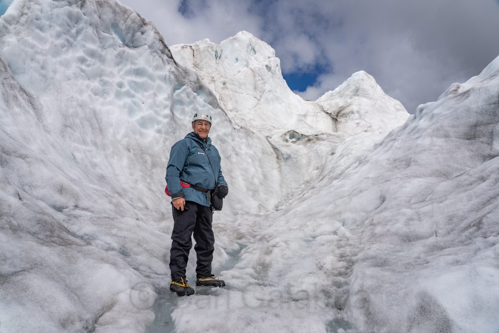
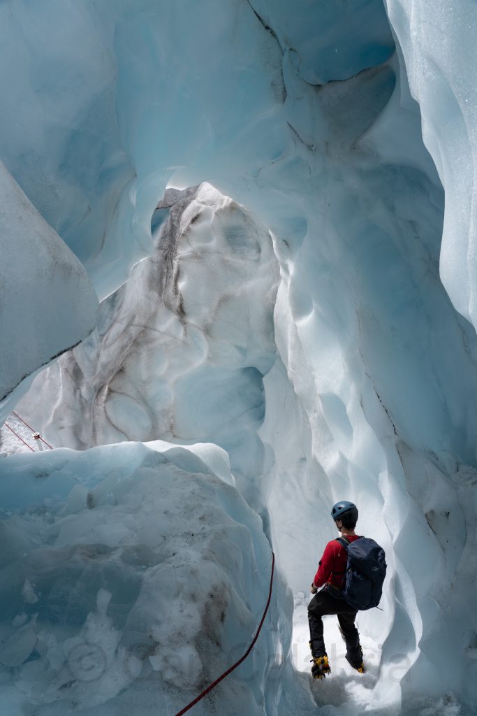
Jeanine and I opted for different activities today. She was interested in a little downtime, and I was looking forward to some up time. I signed on to a heli-hike tour of the Franz Josef Glacier, the fourth largest of over 2000 in New Zealand. A helicopter transported us to the glacier where a guide led us on a 2-hour hike through crevasses, tunnels and over the surface of the glacier. The weather started out perfect but gradually clouds began to develop and we had to finish the last quarter of our hike rather quickly so as to avoid spending the night on the glacier. The helicopters use visual navigation and cannot land if the single landing spot becomes obscured by clouds. When this happens, the group spends the night on the glacier in provided tents and sleeping bags until the weather has cleared. Suffice it to say, I was please that our group made it out ahead of the clouds.
We continued our journey southward, stopping at the Hokitika Gorge for a relatively short hike. The glacial fed river is a brilliant turquoise, fringed by stark white limestone cliffs and lush green rainforest. My photographs do not do justice to the glorious color palette. As is typical in New Zealand, the trails are beautifully maintained and often include swinging bridges that are as fun to traverse as they are to photograph.
With so much candy for the eye in front of you, it is easy to miss what is underfoot even though it is just as exciting. Entoloma hochstetteri, also known as the blue pinkgill, is a species of mushroom that is endemic to New Zealand. It is the only mushroom to ever be featured on a bank note and it has yet to be determined if it is poisonous or not.
Today was ostensibly a travel day during which we stopped several times en route to Punakaiki. Our first stop was at Split Apple Rock whose name says it all. We continued to the Nelson Lakes National Park where we paused for a 1-hour hike at Lake Rotoiti and lunch. Lunch did not include the 4-foot-long freshwater eels which abound here.
Finally, we made our way to the west coast and the Pancake Rocks at Punakaiki. Click on the image below to fully understand where the name comes from.
This evening we are staying in a cabin by the ocean. It will not be remembered as one of our better accommodations, but the view from the beach at sunset was pretty hard to beat.
Jeanine and I spent the day on a kayak tour of the Tonga Island Marine Reserve. The highlight of the day was our encounter with several seal pups playing around in a grouping of rocks, protecting them from potential predators. They were adorable and reminded me of how our kids would play rough and tumble on the couch in our living room.
Jeanine displays a recovered sea urchin.
Here we are at the Tonga Arches. Unfortunately, our guide who took the picture was some distance away and did not know how to zoom the lens.
Dr. Suess Trees, as described by our guide.
Between yesterday’s hike and today’s paddling, I am ready for a less physically exhausting day. Tomorrow we will begin heading south and most of the day will be spent driving.
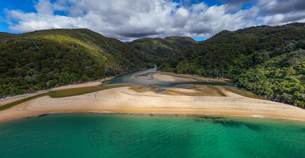
Today, Jeanine and I hiked an 8-mile section of the Abel Tasman Coastal Track, one of New Zealand’s great tracks. We boarded a water taxi that deposited us at Bark Bay, and then we made the 4-hour hike to Anchorage Bay, where we returned to our home base at Kaiteriteri again by water taxi. Most of the trek is in tropical vegetation leaving you unaware of the shear cliff on the ocean side of the path. Occasional, there is a gap in the trees affording views of the ridiculously beautiful beaches.
Bridges are encountered frequently as you traverse the many streams that feed the bays. The suspension bridges were my favorite, reminding me of the hiking I did in the Himalaya.
Bark Bay
Sandfly Bay
Jeanine soothed her feet in Anchorage Bay while we waited for our water taxi.
We bid the North Island farewell this morning as we departed for the South Island by ferry. I spent the entire 3-hour voyage on deck and was rewarded for enduring the chilly wind when a pod of about 100 dolphins seemingly came out to investigate the ferry. During their brief visit, I got several great images.
The ferry route to Picton concludes with a narrow corridor formed between a massive peninsula and the island of Onauku pictured below.
After docking, we drove 2 hours to Kaiteriteri, where we are staying for three nights, steps from the lovely beach.
Our rental car spent most of the day in a downtown Wellington parking garage, a welcome respite from driving for me. We visited the Wellington Museum in the morning. There, I learned about the Wahine ferry disaster. Wellington is the windiest city in the world, and on April 10, 1968, 125 mph gusts in a severe storm blew the Wahine onto the Barrrett Reef causing it to eventually capsize and sink. 53 souls lost their lives in the worst maritime disaster in the countries modern history. Wellington is also well know for early developments in steam power (see model below).
After lunch, we took a 3-hour small bus tour of the entire bay area with a very knowledgeable and funny guide.
A side thruster propeller from the ill-fated Wahine located at a memorial to those who lost their lives.
The final stop was at the base of the famous Wellington Cable Car. We rode up, passing through the colorfully lit tunnels and arriving at the top for a brief tour of the Cable Car Museum and the Carter Observatory.
After the tour, Jeanine visited the Museum of New Zealand Te Papa Tongarewa while I opted to photograph a Pride Day parade happening in the city.
Castlepoint was our destination for this morning. Jeanine hiked up to the lighthouse and took the photo below. I climbed up the central spine of Castlepoint Reef and put my drone to good use. On my way down, I almost tripped over a dozing seal. I am not sure who was more surprised, but I know who ran in the opposite direction as fast as he could. The seal was quite territorial and I was not able to descend past him without risk of being attacked. It took quite a bit of effort but I managed to scale my way down in a different area.
Next, we set out for Wellington, stopping only for the aerial photo below of a typical New Zealand farm and lunch.
Zealandia Te Māra a Tāne is a one-square-mile urban ecosanctuary set around a picturesque reservoir. It is home to some of New Zealand’s most rare and extraordinary wildlife. A perimeter fence keeps all the ground animals inside the park while birds stay for the food they find among the native trees. We toured the sanctuary for several hours before checking in at our AirBnb.
This morning, we drove for 2 hours to the Tongariro National Park, where we spent an equal amount of time hiking to the Taranaki Falls. The weather was perfect, and the 65-foot falls were full with yesterday’s rain. Tongariro is New Zealand’s oldest national park, a dual World Heritage area, and home to three active volcanic mountains, two of which are pictured below. After visiting the park, we drove 4 hours to Masterton. Despite my earlier claims about the lack of straight and flat roads in New Zealand, a good portion of our journey today had such stretches and a speed limit of 62mph which made the trip much less arduous.
Our primary destination this morning was Mount Taranaki in the Egmont National Park. Unfortunately, our good weather luck ran out and we faced high winds and driven rain. We had planned to hike to the Wilkies Pools and Dawson Falls but decided to forgo the former in the interest of safety. The falls were spectacular and more than justified the drive. I had hoped to photograph the three volcanoes in the park but they were covered in clouds while we were there. With a few extra hours on our hands, we decided to stop at Waihi Beach and were greatly rewarded for the detour. The beach is strewn with huge pieces of driftwood and rocks shaped by the waves and wind. During our visit, the wind speed rarely dipped below 20 mph.
Our final destination for the day was the city of Whanganui, where we visited the Durie Hill Memorial Tower before checking into our quaint AirBnb. Once settled we ventured into the downtown arts district where Jeanine purchased a pair of earrings and we enjoyed a Japanese dinner for a change of pace.
The Waitomo area features several limestone caves that are inhabited by glow worms. Only the Ruakuri Cave permits photography inside. It also contains stalactites, stalagmites, curtains, popcorn, and limestone formations of all manner. Access to the cave is by a spiral staircase that is beautiful in its own right. It also makes this the only wheelchair accessible cave in the southern hemisphere. Our guide allowed me to use my tripod for the glow worm photo which would have been impossible otherwise. Even so, the photo is not that great. You really have to see these in person to appreciate them.
After our visit to the cave, we had hoped to hike to the Three Sisters and Elephant Rock. Unfortunately, it started to rain so heavily that we opted to drive directly to our bed and and breakfast in New Plymouth.
Rotorua is known for its rich Māori culture and otherworldly geothermal landscapes. Today, our focus was on the latter. We spent several hours hiking through the Waimangu Volcanic Valley where we were treated to some very beautiful sights. When we arrived at the Waiotapu Thermal Wonderland we had just missed the entry time cut-off of 3 PM so I had to settle for a high altitude drone image so as not to disturb anyone in the park.
Prior to our geothermal adventures, we visited the National Kiwi Hatchery, where we got to see an 11-day-old baby kiwi and three juveniles. Regrettably, photography of birds within the facility is strictly prohibited, so I had to settle for the image below. It is estimated that a total of 25,000 birds remain in the wild and the hatchery has contributed 10% of that number to the total since its inception moving the national icon off the critically endangered list.
Here is what a real baby Kiwi looks like (from the Smithsonian website).
Rotorua is also known for its amazingly dark skies. For the second night in a row, we enjoyed a spectacular view of the Milky Way galaxy. It is a shame that this has become such a rare opportunity for most people.
Neither Jeanine nor I have read or watched the Lord of the Rings or the Hobbits trilogy. At the behest of our kids, who are rabid fans of Tolkien’s works, we included a visit to Hobbiton to our itinerary. I am thankful we did. Even absent context, the place is magically wondrous. The attention to detail and whimsy that can be found everywhere is amazing. Note to kids: These photos are but a tiny sampling of all the photos I shot. We thank you for encouraging us to visit this special place.
After a light snack at the Green Dragon, we drove to Hell’s Gate, a sulfurous geothermal site near Rotorua. It was interesting but not particularly photogenic, and neither one of us was interested in taking the mud baths for which it is best known.
Jeanine learned of a nearby Kiwi bird rescue sanctuary, but we just missed their last tour when we arrived. After reserving a spot for tomorrow, we took a tour of the next-door Agrodome, where we were introduced to 19 species of live sheep, three breeds of sheep herding dogs, watched demonstrations of sheep sheering and the dogs playing (literally running across the backs of all the sheep in the back row) and working (driving sheep into a pen). On a tractor tour of the farm we had a chance to feed the sheep and lamas.
Our day finished with a Mitai Maori Village dinner and cultural experience. We learned about the Indigenous people of the area and witnessed their forms of welcome, celebration, and warfare. I was chosen as Chief of the visitors and had to meet with the local Chief on stage and give a speach on behalf of my tribe (the 200-person audience). Maintaining uninterrupted eye contact was crucial to demonstrate our good will and to prevent the outbreak of hostilities.
The tiny town of Hahei, population 300, receives half a million visitors a year who flock here to visit Cathedral Cove and the other natural wonders of the coastline. We started the day with a boat tour that was both informative and thrilling as we flew over the 1 meter swells en route to the geographic features of the coastline and into the Te Whanganui-A-Hei Marine Reserve. Our fist destination was Cathedral Cove and the arched sea cave for which it is named. Later in the day we would return on foot.
The Orua sea cave, located further south, was equally impressive and large enough for us to maneuver into with the boat.
Mahurangi Island is a sanctuary for birds, sea mammals, fish, turtles. and also features sea arches and caves.
After our boat tour, we hiked back to Cathedral Cove. It was a relatively short 2.6-mile round trip with steep up-and-down sections that left my knees barking by the end. Totally worth it.
In the afternoon, we visited Hot Water Beach where it is possible to dig into the sand allowing hot water to escape to the surface forming a hot water pool. The water, with a temperature as hot as 147 °F, filters up from two underground fissures. Visitors dig large holes and relax and soak in the thermal baths. Click on the overhead aeriel view to observe the many excavations and styles of relaxation.
After Jeanine got her fish tacos at Hotties, we set out for a 2-hour drive to Matamata.
This morning, we set out for the small town of Piha, located on the western coast. There, we hiked to the Kitekite Falls along one of the most beautiful trails I have ever had the pleasure of traversing. Our early start gave us sole access to the falls and basin below. Typically, the latter is full of people splashing about.
We then drove to North Piha Beach, where Jeanine soaked up some sun while I flew my drone.
Rinse and repeat for South Piha Beach.
We then made the 3-1/2 hour drive to Hot Water Beach, located on the eastern coast. Thus far, the roads have been well-maintained, as in a well-maintained roller coaster ride. A straight and flat section of roadway is as rare as the endangered Kiwi birds.
We are staying in what amounts to a tiny house without a bathroom. It is quite adorable, actually. It has a queen-sized bed, a tiny table with a pair of chairs, a dorm-size refrigerator, and not much else. Bathrooms and showers are located in a separate building. There is also a communal pool, food court, and play areas.
Jeanine and I arrived in Auckland at 5 AM this morning. We cleared customs quickly and then spent more than a short while configuring our phones with travel data plans. Unable to contact our rental car agency for pickup, our first hike in New Zealand was to the rental car agency in the rain. Fortunately, it was only a 15-minute walk and we packed light. Our first destination was Mount Eden (Maungawhau), a volcanic peak with hiking and jogging trails leading to views over the Hauraki Gulf. Despite a slight drizzle and heavy cloud cover it was a great way to wake up our legs as we hiked up to and around the ancient caldera. Afterwards, we treated ourselves to coffee and pasteries at a French bakery that Jeanine described as the real deal.
In light of the rain, we decided that our next stop would be indoors and chose the Auckland Aquarium. I was most captivated by the jellyfish displays, although I could have easily spent the entire day watching the penguins in their very realistic habitat.
By noon, the rain stopped, and the skies cleared, so we set out for Waitipu Beach on the western coast, about an hour’s drive from the capital. We practically had the entire black sand beach to ourselves but opted not to go into the water after Jeanine discovered dozens of Portuguese man o’ war washed up on the sand. Their sting will not kill you, but are said to be excruciatingly painful.
Jeanine opted for shore combing while I put up the drone for some aerial photography.
We arrived back in Auckland by 3 PM and visited Auckland University before checking into our downtown hotel.
Jeanine found a lovely Italian restaurant within walking distance, and we enjoyed a stroll there that afforded us a nice view of the Sky Tower.
Jeanine and I arrived in San Francisco yesterday evening after our 7-hour flight, where we boarded this New Zealand Air flight for Auckland. Fortunately, we had strong tailwinds, which cut the normal flight time from 12 hours to 11. For the first time in my life, I was able to sleep comfortably on an airplane. I credit this to a new neck pillow that I purchased and a pair of compressions socks. I can only hope the return flight will be as comfortable.
Jeanine and I leave on a 5-week adventure today. We will spend a month in New Zealand and a week in Sydney, Australia. While we are away, Nico will be house-sitting for us.
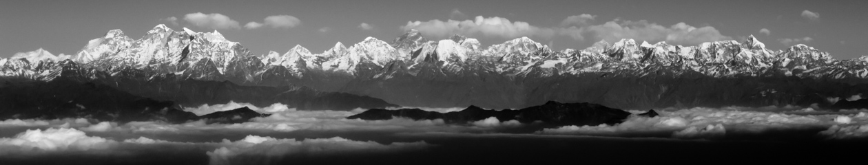
This has been a much-anticipated trip for us, and we are happy that all the planning and preparation is behind us and that we are ready to embark on our journey. I decided to review some of my photographs from past adventures to places of natural beauty and can only hope that I return with as much bounty on this trip.
Pictured above is Mount Fitz Roy on the border between Argentina and Chile taken with my drone when I traveled there with Nico. Below is the village of Gasadalur on the Faroe Islands.
Unified basketball is a sport that combines students with and without intellectual disabilities on the same team to promote friendship and understanding. Nico and Brian Scalabrine were celebrity referees for today’s game at the Concord Middle School. Brian is a current television analyst and former player for the Boston Celtics. They are pictured here with Justin Cameron, the CMS Principal, before the start of the game.
This website is dedicated to sharing, with family and friends, the day-to-day adventures of the Calabria family.