I am afraid my trekking shoes met their match in Nicaragua. I managed to wear off the outside portion of both heels while using my feet to steer and brake on my boarding descent of Cerro Negro. Even though the entire run was probably just over a minute, the scree was so abrasive that it removed a major chunk of Vibram sole from each shoe. This pair of trekkers has served me well and I will be sad to retire them. By my estimate, they have visited more than half the US states and well over a dozen countries.
About half way through my visit to Nicaragua, I discovered that it is illegal to bring a drone into the country without a permit (which is rarely approved) from their equivalent of the FAA. Had my quadcopter been discovered at customs, it would have been confiscated and impounded for the duration of my stay. Getting it back would have involved some serious paperwork and fines. For a moment I considered packing up my kit and mailing it back to the states. I opted instead to continue shooting and take my chances getting back out through customs. In a country where bicycles do not require lights or reflectors, where you can stop your vehicle in the middle of the road to chat with a friend, and where you can walk up to the edge of an active volcanic crater with no barrier, I am not prepared to respect any arguments about restricting drones for safety reasons. While it may get me in trouble at some point in the future, I intend to continue to operate my drone according to the following principles regardless of applicable overly constrained regulations. (1) Do not create a safety hazard for people, animals, or property. (2) Do not invade anyone’s privacy. (3) Do not diminish other people’s enjoyment of a place or event.
With a major Nor’easter forecasted to coincide with my scheduled arrival in Boston tomorrow, l decided to return a day early and avoid the inevitable canceled flight and night spent sleeping in the Miami airport. En route to the Managua airport, I stopped briefly in the capitol to take in a few of the sights. Pictured above is the Santiago of Managua Cathedral and below one of the Trees of Life (a virtual mini-forest can be found throughout the city, commissioned by Rosario Murillo, the omniscient and omnipotent wife of President Daniel Ortega.)
More than any other photo I have taken in Nicaragua, the one above best captures the essence of the country for me. Happy, proud, and friendly people with close family bonds and strong work ethic. Dusty and rock-strewn dirt roads traveled by more horses than cars. This mother and her daughters seemed to be chasing to catch up with the truck I was riding in on the way to the Telica Volcano for a sunset crater ascent. From the top, you can see a dozen or so of the volcanic peaks that form the Ring of Fire within Nicaragua. I actually found the moonrise to be more photogenic than the sunset and the view of the magma to be less than impressive. Still, I enjoyed the climb and the company of a family from Sweden who made up the rest of our group.
The descent by flashlight was trying on my knees but otherwise uneventful until our guide spotted a scorpion. The first I have ever encountered in the wild you know I had to stop for a photo.
Earlier in the day I drove to the coastal towns of Poneloya and Las Peñitas where I found beautiful beaches, abundant birdlife, and laid-back beach bars and beachgoers (all 5 of them).
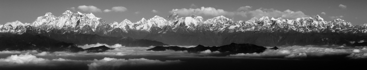
Cerro Negro is an active volcano that has erupted 23 times since it was formed in 1850 and most recently in 1999. It is basically a steep black mountain (sides are a mixture of burnt sand and stones that give it a dark tone) with no vegetation. The climb to the top took about an hour revealing a spectacular view of the crater and nearby volcanoes Telica and San Cristóbal. Scrape away a half inch of the surface and you can feel an enormous amount of heat emanating from below leaving no doubt that this mountain is very much alive. Click on the wide-angle panorama to best appreciate the beauty of the surroundings.
Reaching the mountain is best done with any one of the tour groups that come here for the “volcano surfing.” Given that my knees much prefer ascending than descending mountains, the idea of climbing to the top and sliding to the bottom was very appealing. My tour provided the “surf board”, protective jump suit, googles and gloves. Traveling at speeds of 50km/hr is quite the thrill but not without intrinsic danger. It is also important to protect your face from the flying stones. I fashioned a buff from a child size tee shirt I purchased in León the day before. While this activity is better suited to the twenty year olds in my group, I managed the fastest run that did not result in a crash. I followed the directions exactly; legs out for stability, both hands on the handle, lean back for speed and low center of gravity, stay on the course. The bulge in my midsection is not a result of weight gain but rather where I stored my camera for the descent.
The guy who followed me down was easily doing 70km/hr until he lost control and wiped out.
I was pretty tired by the time we returned to León so I decided to relax and do a little people photography.
León of all the larger cities I have visited thus far seems the least affected by tourism. On this Saturday night the central square was filled with families, young and old, enjoying a festival like atmosphere with no regard or interest in the foreigners. Pictured here are the Iglesia La Recoleccion and the Catedral Basílica de la Asunción two of the most prominent churches.
The drive from San Juan del Sur should have taken 3 hours based on distance and speed. Numerous construction delays and a mile-long procession of horse and oxen drawn thatch covered wagons (some of which are pictured below) added another two to the journey.
Along the way, I stopped for some fresh fruit at the stand below. These can be found almost everywhere throughout the countryside. As I enjoyed my snack, I watched two girls riding past on a bicycle. Bikes are used extensively here but what I found odd about this scene was that the smaller of the two girls was doing the pedaling.
San Juan del Sur is know for its pristine crescent shaped beach and spectacular sunsets. I arrived at about 1PM and was surprised to find the beach absolutely vacant. A short stroll in the sand and I realized that it was simply too hot for anyone in their right mind to be out. I followed suit and decided to visit the 25m tall Cristo de la Misericordia statue which overlooks the bay.
Before departing Ometepe I had about an hour to spare and put the time to good use in a nature reserve near the ferry “terminal.” I managed to capture this pair of butterflies (it took no less than 100 exposures to get one keeper) and a Howler monkey (with baby) which made for a pretty nice way to pass the time.
The town comes alive when the sun goes down and cool breezes blow in from the ocean.
Pictured above is my lodging for the two nights I am spending on Ometepe. It is a horse ranch located at the base of the Maderas Volcano in the town of Merida. I got an early start on a hike to the San Ramon waterfalls and managed to arrive 40 minutes before anyone else. This gave me plenty of time for photography before the place was overrun by hikers eager to bask in the cool spring fed waters. On the hike I encountered both Howler and Capuchin monkeys and an amazing variety of birds and butterflies.
The little fellow below is actually one of two parrots that reside at the finca where I am staying. Each greets me every time I enter the dining area with very polite “holas.” Their wings are clipped so they never leave this tree except to come in for the evening. They are joined by half a dozen Chihuahuas, three large dogs, several cats, and more than a dozen horses who share the farm with the guests.
My destination for this evening was Ometepe, an island in Lake Cocibolca which was created by two volcanoes, Concepcion and Maderas. To say it was a challenging travel day would be an understatement. My 2:30 PM ferry reservation was bumped (the ferry company said they needed to send one of their own cars to the island). This forced me onto a later one which did not arrive until the sun was just setting. While this afforded me nice light for the photo above, it also meant that I would make the one-hour drive to my lodging in Merida at night. It should be noted that there are no street lights, no reflectors or lights on bicycles, unmarked speed bumps, and all manner of animals on the road (small pigs and dogs are the hardest to see but dark-haired horses are a close second.) When I arrived, the electricity lasted just long enough for the friendly staff to make me a fresh fruit smoothie which I enjoyed more than I can say.
For only the second time in my life, I had a chance to photograph molten lava. The first time was in Costa Rica on Mount Arenal and that photograph leaves much to be desired. Today I visited the Mayasa Volcano. Once early in the morning to scout the best shooting position and again at dusk when the molten lake within its crater would appear the most dramatic. Even more impressive than the sights and smells was the sound. Attempts to describe it with words fail me. Definitely left me with great respect for the forces of nature which continue to shape our planet.
I spent the rest of the day driving around the area including a lunch stop at a restaurant with a perfect view of Laguana Apoyo, a volcanic crater lake.
There seemed to be no end of interesting subjects to photograph as I completed the journey from Mayasa to Granada. Below is a small sampling. I particularly like the one of the legs sticking out of a restaurant window. They belonged to a little girl who was neither trying to crawl in or out but rather just enjoying being in limbo. I showed the picture to the girl and her mother which elicited much laughter. They spoke no English and I just a smidge of Spanish. The image told the story and needed no words in any language to explain or embellish it.
With a third Nor’easter forecasted to dump a foot or more of snow on Concord today, my plans for a quick travel adventure could not have been better timed. I left this afternoon for a 9-day visit to Nicaragua, flying by way of Miami (pictured above). I arrived in Managua after dark and managed to clear customs, gather my rental car, and secure local currency in record time. Driving here is like the rest of Central and South America, not for the faint-hearted. I took it extra slow as I adapted to the new car, local traffic “customs,” and nighttime navigation. I arrived at my hotel without incident, if not thoroughly exhausted and soggy from the 97-degree temperature. Meanwhile, Kyle is headed to Minneapolis for a visit with his cousin Rory leaving Jeanine alone with Nala to cope with the snow. I know this sounds bad but neither of us could have anticipated the storm and I did offer to take Jeanine to Hawaii instead but her work obligations and the duration of travel made that impractical.
When Maya left for college, Jeanine and I started to think about downsizing. Our current home of 15 years has served us extremely well while there were five of us under the same roof. Now that we are empty nesters, we are starting to think about a next home that is better sized for this new phase of our lives. We had talked about putting the house up for sale this spring but decided to postpone by a year when I failed at retirement and found myself in the fast lane again. All this was until Jeanine learned of a potentially interested buyer who came to look at the house today. They appear interested and it certainly would be convenient to sell the house after one showing and without a realtor commission. It remains to be seen if we will be able to agree on a price or if their interest wanes but it has us seriously thinking about the possibility.
This evening I enjoyed watching the US Paralympic Sled Hockey team as they racked up an impressive 10-0 win over Japan. The youngest member of the team, Noah Grove (22), is also a member of the US National Amputee Soccer Team. A truly wonderful young man and incredible athlete, I was thrilled to watch as he scored his first Paralympic goal late in the first period. I was tempted to call Nico to see if he was watching the game but thought the better of it given the late hour. I think team USA has a good chance of medalling and have set the DVR to record all of their matches.
Today riders of the Copenhagen Wheel surpassed an aggregate total of one million kilometers. For our very young company, it was a momentous milestone and cause for celebration. With spring weather around the corner, I am gearing up to add to this total on my own CW bike.
This website is dedicated to sharing, with family and friends, the day-to-day adventures of the Calabria family.