I did not bring any shaving gear with me to Nepal and returned with a scrubby beard. All the men I run into say I should keep it. All the women say it should come off. I plan to keep it for about a week and then this photo, taken by Maya, will be the only record of its existence.
My effort to obtain a seat assignment on the left-hand side of the plane for my flight from Kathmandu to Bangkok was immediately rewarded with views of the full Himalaya range including Mount Everest as we broke through the clouds after takeoff. What an incredible sight to end my visit to Nepal. From Bangkok, I fly to Frankfurt, and then on to Boston for a total trip duration of 36 hours.It is hard to complain about the less-than-ideal routing given I used frequent flyer mileage to obtain my tickets. The time is put to good use as I set a goal of deleting at least half of the 6000 photos I took during this vacation. Once home I will seek to further reduce that number to 1000.
The Chorten Chempo in Bouddha is one of the largest stupas in the world and the most important Tibetan Buddhist monument outside of Tibet. The stupa has been sealed for centuries and no one knows for sure what it contains although it is widely believed to contain parts of the Buddha’s body (bones, hair, teeth) and other holy relics. Is is said that one spin of a prayer wheel here is the equivalent of reciting the mantra embossed on it eleven thousand times.
By mid morning I began walking to Pashupatinath, Nepal’s holiest Hindu pilgrimage site. The Pashupati Mandir is the main temple but entrance is restricted to Hindus only although I was permitted to go as far as the entrance gate and look inside. Here also is where cremations are performed on the banks of the Bagmati River. During my 4 hour visit, I witnessed as many cremations including one for a high ranking dignitary complete with a military guard and band with the General of the Nepali Army in attendance to pay final respects. Bodies are carried to the river where they are dipped in the water three times, the feet are cleansed and clothing removed (discreetly under covers). The body is then placed on a riverbank ghat (raised platform) on top of a bed of logs. The chief mourners (typically the eldest sons) circle the body three times and then set it on fire (face first, which I found to be somewhat disturbing). It is then surrounded by additional logs and covered with wet reeds to keep flames from erupting. Smoke is carried to the heavens for hours before the body has been fully consumed. I found the cremation ceremony to be very poignant and beautiful but had trouble reconciling that image with the level of pollution in the holy river which I can only describe as a sewer.
I find traditional Hindu religious attire to be very photogenic and enjoyed making several portraits as I surveyed the crowds from a distance.
The ancient Newar town of Bhaktapur, located 30 minutes by bus from Kathmandu, was my favorite cultural destination. It was cleaner and less commercial than the other places I have visited and one can imagine that this is what Kathmandu must have been like in bygone times. I spent the entire day roaming within the gates of the old city.
The siblings pictured below are children of the street. At no point during several visits to this particular square over the course of the day did I see a parent anywhere. The older girl never let the baby from her arms. What they did for food I have no idea.
The city is graced with carved wood at almost every turn. The artisan seen working here was preparing a new railing for the guest house in which I was staying. All the work is done by hand.
Durbar Square in Bhaktapur was easily my favorite cultural destination. The architecture and craftsmanship are unrivaled and the layout of the square is more open than most others by virtue af an earthquake that destroyed many of the original structures.
Yesterday I complained about all that is wrong with Kathmandu. Today I covered about 25 miles on foot trying to capture images of all that is good. Most tourists take taxis between the main attractions. By walking you get a much more intimate view of the city. In no particular order.
As I was getting ready to make the 8 hour bus trip back to Kathmandu, I noticed a very unusual scene. A man suspended by a rope was collecting honey with little apparent regard for the swarm of bees that was attacking him as he did so. No amount of money in the world could induce me to perform this work in this fashion. I departed with a greater appreciation for the honey I was having each day with my lemon tea. The bus ride went quickly as I spent the hours conversing with a young woman who worked in Bhutan as an eco-tourism adviser and was in Nepal visiting friends. That evening I found a quiet guest house and went out for a nice dinner at an Indian restaurant.
Tomorrow I will walk throughout the city visiting the many cultural sites in the area. My photographs will be carefully taken to show all that is beautiful. Today, however, I must comment on the fact that Kathmandu is the most polluted city I have ever visited. It is truly depressing to witness what little regard the Nepalese have for their environment. The air is thick with smog from unregulated engine emissions, the open burning of trash, and the use of fires for cooking and heating. The rivers and waterways are filled with garbage and sewage. Residents urinate, defecate and spit where they please. Car and motorcycle horns are beeped incessantly all day long and well into the night. People discard refuse and organic waste wherever they are standing. The homeless live in squalor. It is hard to imagine how people who can be so friendly to strangers can be so uncaring for their own environment especially in a country so blessed with natural beauty.
I logged another 10 miles this morning while making the return hike to Sauraha with my two guides. We saw very little in the way of wildlife but did arrive just in time to watch the local elephants bathing. Handlers scrub their elephants from top to bottom and all involved seem to really enjoy the daily ritual. Hearty spectators can climb on top of an elephant if they wish to take a very cold shower.
Once cleaned, the elephants return to duty carrying up to four passengers at a time into the jungle. I joined one such tour this afternoon and was treated to several wildlife sightings including a mother and baby rhino.
At day break I met my guides by the river where we started our two day jungle trek with a 4 mile boat ride in a dug out canoe. Dense fog reduced visibility to almost nothing. Our boatman clearly knew every rock in this river and guided us expertly downstream even though we could only hear the rapids as he set up for them. A few miles in, the head guide whispered to the boatman who quickly brought as to shore. We scampered up an incredibly steep bank and then stood silently until we could hear the sounds of a very big animal moving through the brush. I was instructed to climb the nearest tree as did my guides. In a few minutes a huge one horned rhino emerged from the mist. Their eyesight is rather poor but they have excellent hearing and a great sense of smell. We waited patiently in our perches and I was treated to some great photos as this magnificent animal, one of 2000 remaining in the world passed below my tree.
When the coast was clear we climbed down from the trees and returned to the boat to complete our downstream journey. After landing, we set off on a rather brisk pace through the jungle. Having just returned from high altitude and with three days of recovery time on my blisters I was moving in high gear. We covered no less than 20 miles during the ensuing 9 hours and I could have easily gone further. During that time we encountered all manner of wildlife as documented below and paused for lunch in the safety of an observation tower. We spent the night in a small lodge just outside the park which we reached just as the sun was setting.
Although portions of the Annapurna Circuit were more dangerous than I had expected, I must say that nothing compared to the risk of riding the buses in Nepal. I left early this morning on a 7 hour journey to the Chitwan National Park located near the southern border with India. Much of the bus route is along a narrow road that is carved into the sides of the mountains. Between the terrible conditions of the roads, the lack of maintenance on the vehicles, and the generally reckless nature of the driving, one could expect to see a disabled vehicle or accident every thirty minutes or so.
The city of Sauraha, located on the Rapti River, is the eastern gateway into Chitwan, the first national park in Nepal. It was established in 1973 and granted the status of a World Heritage Site in 1984. It covers an area of 360 square miles, mostly jungle, and visitors must be accompanied by two guides (forward guard and rear guard). I shunned the group packages and hired two local guides this evening and made arrangement to meet them at sun up. I spent the remainder of the day exploring near the river.
Pokhara is the third largest city in Nepal with a population of 250,000 and is situated on beautiful Phewa Lake where visitors can rent boats for a day on the lake or to visit the Taal Barahi Temple located on an island in the middle. I spent most of the day reading by the water with my feet up. I have the complete works of Sherlock Holmes on my iPhone and finished several volumes while my toes basked in the sun. I did manage a few photos that did not require much walking.
In light of my badly blistered feet, I have decided to skip the remaining down hill section of the circuit. Instead I will fly to Pokhara for a day or two of rest and recovery before heading further south where I will continue trekking in the jungles of Chitwan National Park. The 40 minute flight through, rather than over, the mountains was delayed by 5 hours. I was told that this is quite normal and that some people are forced to wait for several days for clear weather. The saying here goes; “The clouds have rocks in them”. Planes on this route are not equipped with avionics so pilots must rely on visual navigation.
I spent more time people watching than walking today hoping to give my blisters a chance to heal. Soccer is played everywhere and you are as likely to see girls playing as boys.
I treated myself to a 90 minute massage which did wonders for my aching muscles and left me entirely relaxed for the remainder of the evening which ended in a nice sunset.
A long day of descent featured a visit to the romantic fortress town of Kagbeni located in the Kali Gandaki River valley which defines the western side of the Annapurna circuit leading all the way down to Tatopani. Here one finds medieval buildings and terracotta Buddhist figures with interesting details (examine the photo carefully).
Extensive use of terraces enables the agriculture needed to sustain the local community.
I enjoyed lunch here while observing the locals at work and leisure.
Covering a lot of ground, I continued down the desolate and wind blown Kali Gandaki River valley until I reached Jomsom by which time I had developed a serious set of blisters under the toes of both feet and on the heel of my left foot.
Most people consider the climb over the Thorung La Pass (at 17,769 feet) to be the most difficult day of the Annapurna Circuit trek. You start before the sun is up and will not arrive in Muktinath much before sun down. It is a long day with a huge ascent and an even more punishing descent. For me it was a piece of cake compared to yesterday because the trail was not nearly as treacherous. The downside of doing this trek in December is that it is very cold and the winds can be very strong. My hydration reservoir water line froze in my first five minutes on the trail. A rookie mistake, I failed to blow air back into the tube after taking my first sip. That mistake cost me dearly as it meant no water until it thawed at about 2PM, 8 hours later. At the top of the pass, I paused briefly for pictures.On the trail the winds seemed to be in the 30 mph range. At the top of the pass I would say they were closer to 50 mph and the windchill was insanely cold. My gloves came off for only a millisecond as I set the timer on my camera and tripped the shutter. I had to spread the legs of my tripod to their most extreme angle to prevent the wind from knocking my camera over. The descent took its toll on my knees but with every step the air got thicker, the winds weaker and the temperature warmer. An entirely new set of views appeared and a real sense of euphoria set in. Perhaps this or the lack of water caused me to take a wrong turn. I descend down the wrong side of the valley and had to add an hour to an already very long day to correct the mistake.
The nature of the trail changed dramatically today. Wide and flat has given way to narrow and slanted. Stable sand and rock has given way to fickle scree fields, often covered in ice. If I had to pick a single word to describe the situation I would say treacherous. In many places a single missed step would result in a long uncontrolled fall to certain death. For the first time on the circuit I was unable to manage my fear of heights and found myself paralyzed, unable to move forward and unable to retreat. In every case, I eventually forced myself to move forward as the fear of what was yet to come was never as great as the fear of what I had already been through. There was simply no going back and I knew that I would make it over the pass tomorrow because no force on Earth could compel me to travel this trail again. Most people have no more trouble on the trails today than yesterday and would be more likely to complain about how hard the elevation gain was in thin air. For the acrophobic, however, there is a world of difference. Had I known how psychologically challenging today’s trekking would be I would have never started the circuit. Now that I have done it, I would never do it again. That said, I feel a real sense of accomplishment having pushed through my irrational fears and making my way to High Camp. None of today’s pictures illustrate the portions of the trail which caused me terror. Once my anxiety gets triggered the simple act of taking a photograph becomes absolutely impossible. All I am able to do at this point is tighten my grip on my trekking poles, narrow my field of vision to the trail under foot and take one more step and then force myself to breath.
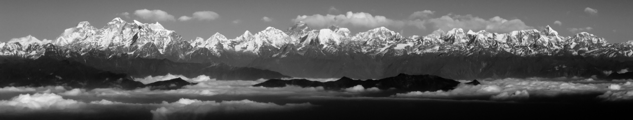
Above High Camp is a ridge leading to a viewpoint said to offer an exceptional panoramic view. Just looking at the trail I could tell this would be another test of my acrophobia but kept telling myself I had not come this far to miss one of the best photo opportunities of the trek. I had to get on my hands and knees at the very end but I made it to the top and can say it was absolutely worth the effort. I eventually mustered the courage to stand up so that a fellow trekker could take my photo in this spectacular setting.
All in High Camp that evening would be trying to make it over the pass tomorrow and that shared challenge made for a strong sense of camaraderie. We all huddled together to fight off the cold before we turned in for the night.
This website is dedicated to sharing, with family and friends, the day-to-day adventures of the Calabria family.